Harper’s History of the War in the Philippines
Cover Title
Title
- Item:
- Title:
- Harper’s History of the War in the Philippines
- Author:
- edited by Marrion Wilcox
- Printer:
- Harper & Brothers
- Place of Printing:
- New York and London
- Date of Printing:
- 1900
- Format:
- Elephant Folio. 16.5 x 12 inches
- Language:
- McCune Location:
- Reference:
Author and Commentators
Marrion Wilcox (1858-1926) was born in Georgia. He graduated from Yale University in 1878 and received his L.L.B. from Hamilton College and was admitted to the New York Bar. Wilcox acted as an instructor at Yale and wrote A Short History of the War with Spain and Harper’s History of the War in the Philippines.
The Book
Approximately 473 pages. Contains a listing of the U.S. soldiers by rank on pages 413-465. Extensively illustrated and containing numerous maps. Approximately twenty-six full-page colored illustrations and over a thousand black-and-white illustrations and photograph. On page 384 there is an illustration of General Lawton by Frederic Remington. Some of the war correspondences contributing to this book were John F. Bass, William Dinwiddie, and Frank D. Millet. There are also accounts by the officers commanding the actions such as Admiral Dewey and Generals Greene, Lawton, Merritt, and Otis.
Contents
This book discusses the war in the Philippines from1899 thru 1900). It covers the insurrection of 1896 by the Filipinos against Spain, the revolutionary government of Emilio Aguinado et al. and the pact of Biak-na-Bato, in which the Spanish government ended hostilities with the revolutionaries by granting amnesty and paying them a monetary indemnity. Then in April 1898, the Spanish-American War began. Admiral Dewey brought his squadron to Manila to defeat the Spanish squadron under Admiral Montojo.
Although the Filipinos had fought against the Spanish and controlled much of the Philippines, the United States did not recognize Philippine independence. Filipino troops were not allowed to enter the city of Manila which had been captured by the Americans. The Spanish seceded the Philippines to the United States at the Treaty of Paris in 1898.
The declaration of independence by Emilio Aguinado was not recognized by the United States. This let to conflict between the American and Filipino forces.
In February 1899, an American soldier on guard duty shot a Filipino officer who refused to stop when challenged. This lead to the start of the war with the Filipinos under Aguinado. Brigadier General Wheaton led a flying column to cut communications between the north and south insurgent armies. The Americans under Arthur McArthur soon overtook Maloslos (the first insurgent capital) and then when the capital was moved to San Isidro and Cabanatuan, these were also captured.
The American army pursued Emilio Aguinado and his government throughout the Philippines. But the war did not always go the American’s way. In 1899, Lieutenant Gilmore and twelve sailors were captured off the coast of Luzon. After marching them for quite a distance, the Americans were to be executed but were saved due to other American troops being in the area. During the night the Filipinos left their prisoners and escaped. In November 1899, the cruiser Charleston was wrecked off a reef near Luzon. In another incident, Brigadier General Henry Ware Lawton was on the battle lines in San Mateo in December of 1899 when he was shot and killed by an insurgent sharpshooter.
Although not included in the book, the war began to come to an end during the next few years. Finally, in 1901, Aguinado was captured and accepted the authority of the United States over the Philippines. However, General Malvar took over the government and continued guerilla operations. He did not surrender until 1902.
Contents
- How Magellan Came To Cebu
- How the Philippine Islands Received Their Names
- The Final Revolt Against the Spaniards
- The Overthrow of the Spanish Dominion in the Philippines
- To the Philippines with American Troops
- The Vain Hope of Independence
- The Third Battle of Manila
- From the Attempt to Destroy Manila to the Flying Columns Success
- On to Malolos; the Taking of the First Insurgent Capital; the Santa Cruz Raid
- The Taking of the 2nd and 3rd Insurgent Capitals
- Military Operations East & South of Manila in June 1899; Luzon & Visayas
- Progress in Central & Southern Islands; Constitution-making in Negros; Treaty-making in Sulu
- Contrasts: Naval Activity in Philippines, Admiral Returns; Typical U.S. Regiment
- Attempt to Capture Aguinaldo; Loss of the Cruiser Charleston; Garrison Life
- Pursuit of Aguinaldo; Luzon Highlands; Lt. Gillmore Captivity; General Lawton
- Last Expeditions
- Agriculture, Commerce, Transportation
Appendix
- Treaty with the Sultan of Sulu.
- Troop F. Third Cavalry.
- Brigadier-General Grant’s Report.
- Report on Battle of San Mateo.
- American Volunteer Soldiers.
- The Astor Battery
Gallery
 Native Types
 Natives of Taguig
 Gates of Old Manila
 Rice Fields
 President Aguinaldo
 Leaders of the Insurrection
 US Ships
 Filipino Leaders
 Filipino Leaders
 Luzon Highlanders
 Commanders and XO's of the Squadron
 Manila Scenes
 Corregidor
 Aguinaldo's Manifiesto
 Igorrote Spearmen
 Cathedral as Prison
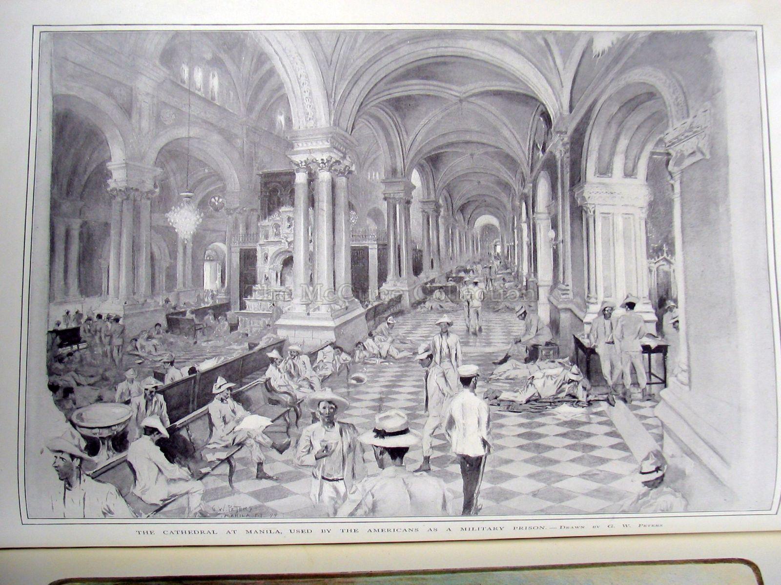 Major-General E.S. Otis
 Train at Caloocan
 Luzon
Luzon
 General Arthur MacArthur
 Glimpses of the Expeditions
 Third US Cavalry
 Charge by Carabaos
 Filipino-American Supreme Court
 Field Mess
 Visayan Family
 Moro Village
 Moros of Mindanao
 Sulu
Sulu Moro Warrior
 Sailors on Flag-ship Olympia
 Dewey's Sailors
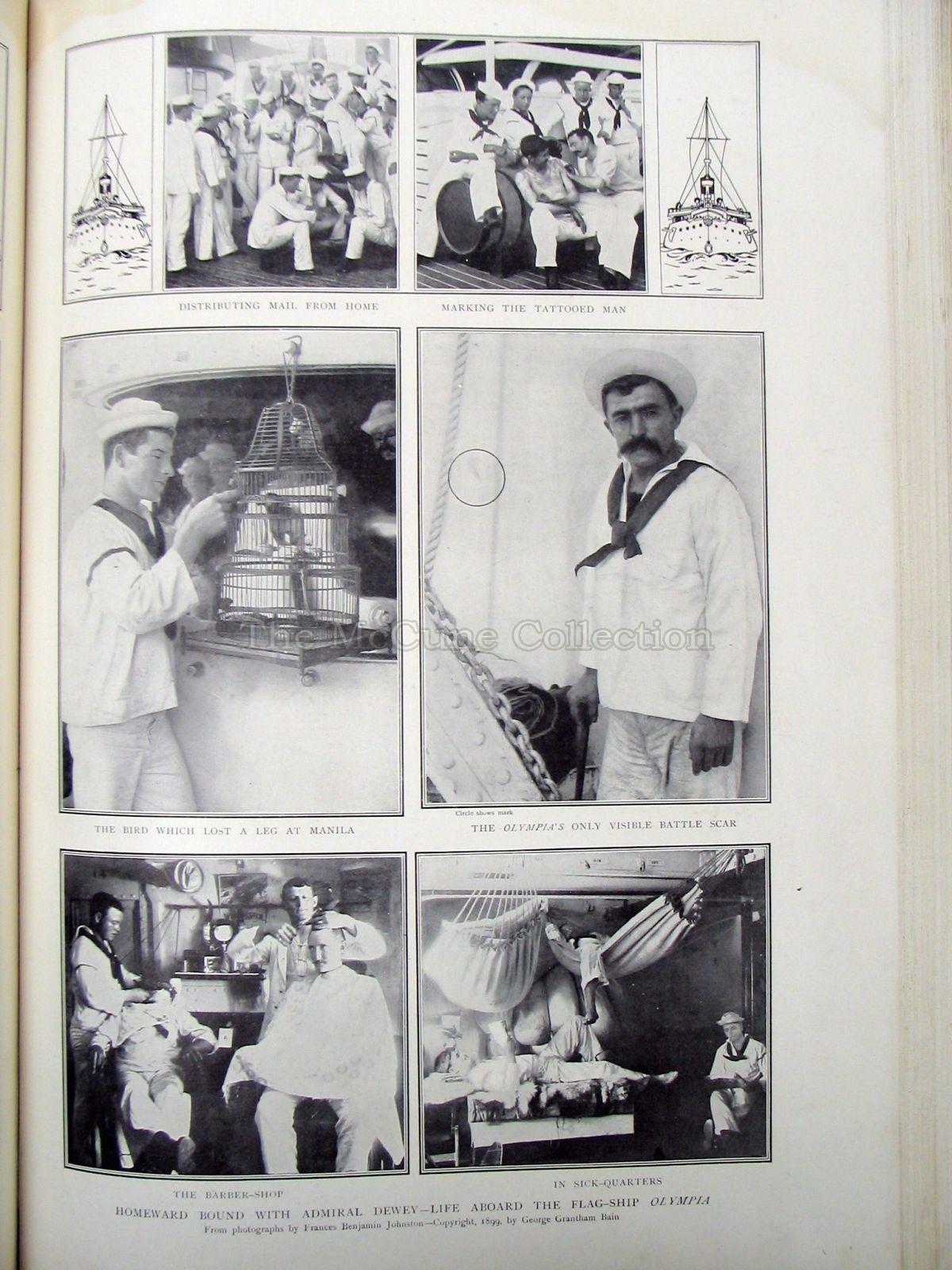 Dewey's Squadron in NY
 Street Band in Tondo
 Filipino Soldier
 Taylor's Guns
 Macabebe Scouts
 NW Luzon Natives
 General Lawton
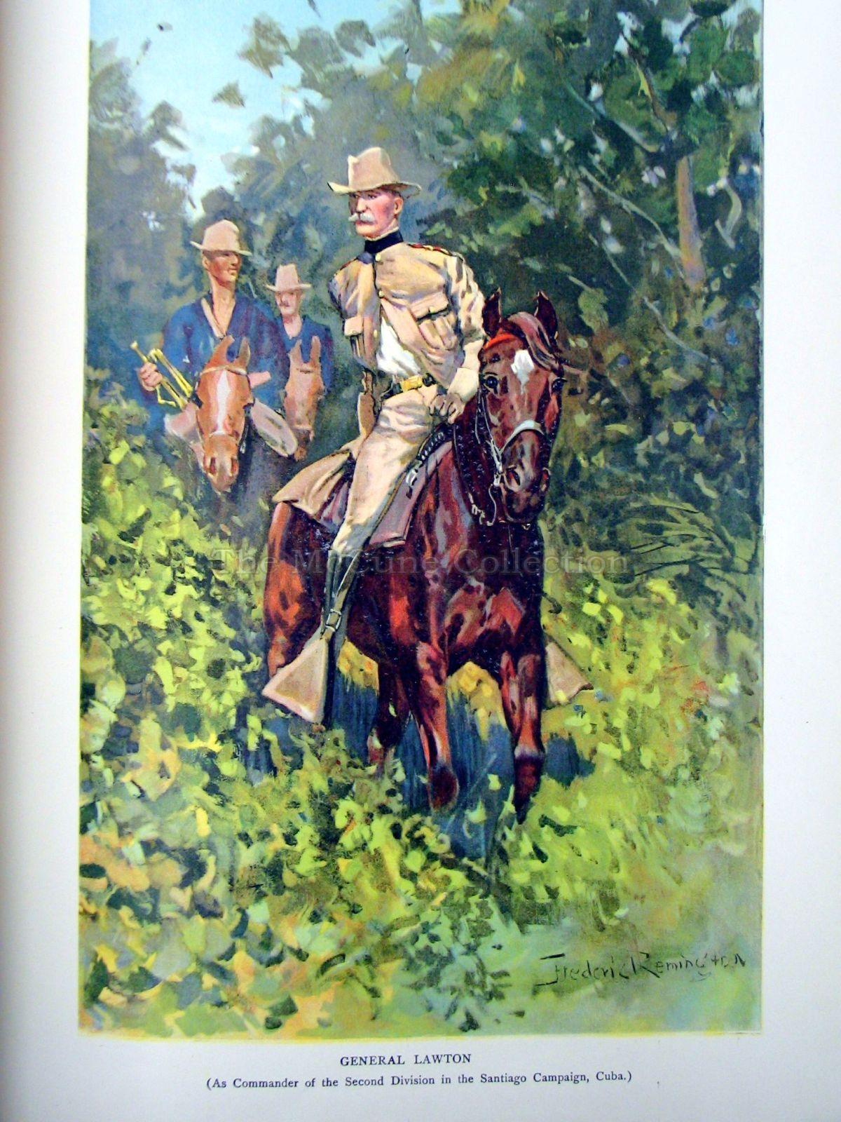 Holiday-Time
 Mount Iriga Native
 Military Map
 A Dato
 Returning Home
 General Lawton & Staff
 General Lawton
 Col John M Stotsenburg
 General Lawton
 CoverTitleContentsChp 1
 Native
 Chp 2
Chp 2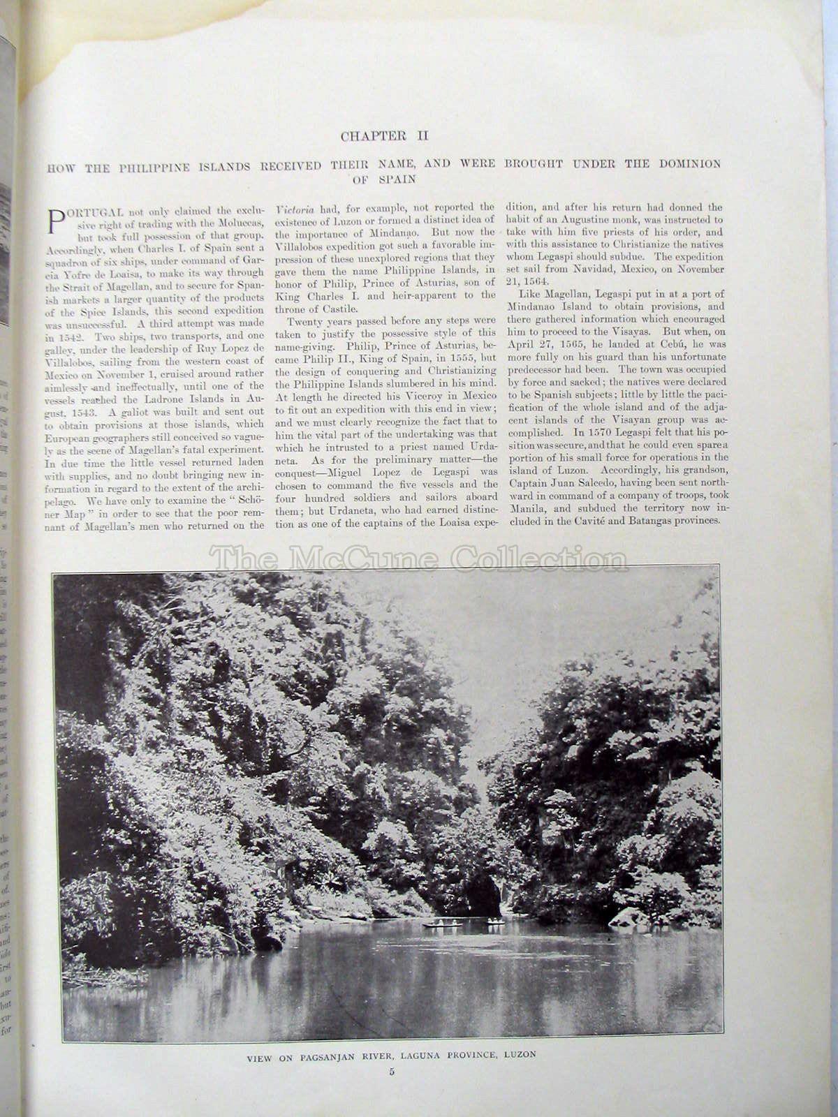 Flag of Truce
 Magellan
 Magellan
 Map
Map Luzon Higlanders
 Luzon Highlanders
 President Aguinaldo
 Insurgent Regiment
 Filipino Leaders at Ilo Ilo
 Aquinaldo's Headquarters
 Aborigingal Chief & Escort
 Iowa Regiment Officers
 Supreme Court of Manila
 Felix Cuenca
 Young Sultan & Attendant
 Dato Amir Hussin
 Dato Calbi
 Apolinario Mabini
 Aguinaldo's Wife
 Del Pilar & Torres
 Ricardo & Mascardo
 Pana & Garcia
 Cardenas & Prieto
 Bellarmino & Luna
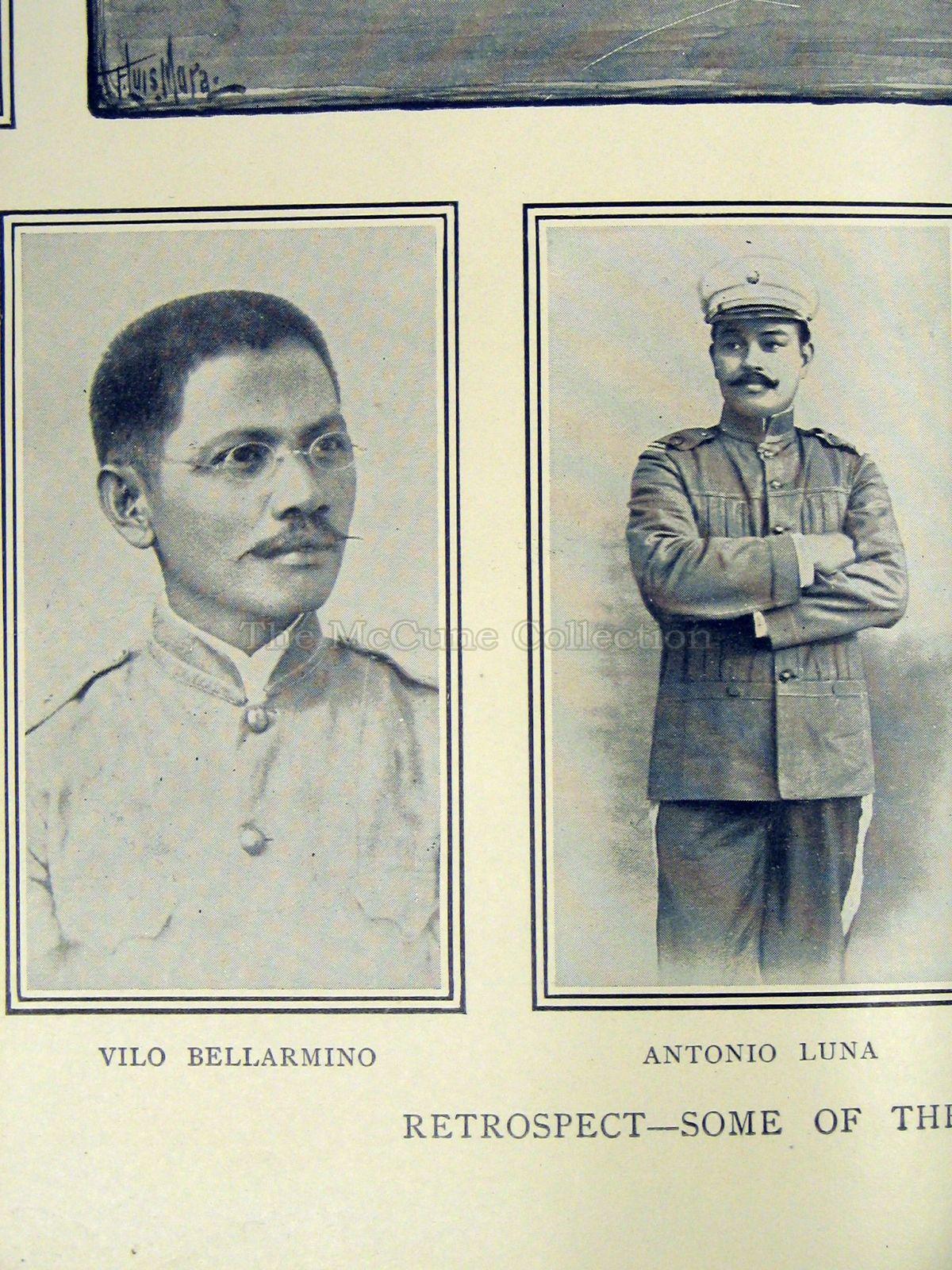 Paterno & Lionzon
 Pio Del Pilar
 Leaders of the Insurrection of 1896
 Moros of Mindanao
 Visayan Family
 Natives
 Holy Week
 Old Manila
 Rear Admiral Patricio Montojo
 Ships
Ships Naval Officers
 Guam
Guam Agana
Agana Map of China Seas
 Advance Toward Manila
 Soldiers
 Gen Merritt
 American Troops
 First Filipino Congress
 Filipino Leaders
 President Aquinaldo
 Rice Fields
 Manila
 Igorrote Tribe
 Filipino Warriors
 Firing Line
 San Pedro Macati
 Insurgent's Attempt to Burn City
 Troops
 Prisoners
 Military Prison
 Train
Train Insurgents
 Action Exercise
 Admiral George Dewey
 Army Transport
 HQ 2nd Oregon Volunteers
 Brigadier-General Hall
 E.S. Otis
 Luzon
Luzon Brigadier-General Funston
 Arthur McArthur
 Expeditions
 Municipal-Home Rule
 Carabaos
 a Mess
 Hospital Ship
 Moro Village
 Dato
Dato Moro Warrior
 Olympia
 Dewey's Sailors
 U.S.S. Olympia
 Adm Dewey
 Dewey Arch
 Sailors
 Sailors
 Ships
Ships Ships
Ships Band
Band Gathering
 Filipino Soldier
 Artillery
 Wheaton's Expedition
 Macabebe Scouts
 Natives of Luzon
 Gen Lawton
 Train Wreck
 Map
Map
 Map
Map Dato
Dato Hospitals of Manila
 Wounded
El Ingenioso Hidalgo Don Quixote de la Mancha (1780)
This tale of Don Quixote was published in 1780 by the Spanish Royal Academy in Madrid, Spain. It consists of a four-volume edition containing a detailed map of Spain as well as over thirty engraved illustrations. It is considered the most magnificent edition of the tale ever produced. The map allows the reader to follow Don Quixote's itinerary throughout the story and the decorative engravings (one per chapter) helps illustrate the situations he faces. This publication contains a biography of Cervantes, an analysis of the tale, and an engraved portrait of Cervantes designed by Jose del Castillo. The edition was printed by Spain’s premier printer, Joaquin Ibarra, and no expense was spared to make it the best.
 Don Quixote
 Don Quixote

Part 1
 El Ingenioso Hidalgo Don Quixote de la Mancha (1780)
 El Ingenioso Hidalgo Don Quixote de la Mancha (1780)
 El Ingenioso Hidalgo Don Quixote de la Mancha (1780)
 El Ingenioso Hidalgo Don Quixote de la Mancha (1780)
Part 2
 El Ingenioso Hidalgo Don Quixote de la Mancha (1780)El Ingenioso Hidalgo Don Quixote de la Mancha (1780)
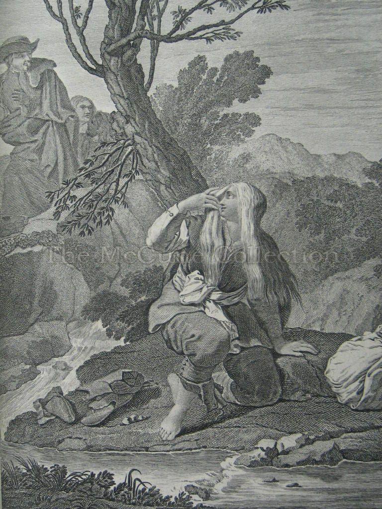
 El Ingenioso Hidalgo Don Quixote de la Mancha (1780)
 El Ingenioso Hidalgo Don Quixote de la Mancha (1780)
 El Ingenioso Hidalgo Don Quixote de la Mancha (1780)
 El Ingenioso Hidalgo Don Quixote de la Mancha (1780)
Part 3
 El Ingenioso Hidalgo Don Quixote de la Mancha (1780)
 El Ingenioso Hidalgo Don Quixote de la Mancha (1780)
 El Ingenioso Hidalgo Don Quixote de la Mancha (1780)
 El Ingenioso Hidalgo Don Quixote de la Mancha (1780)
 El Ingenioso Hidalgo Don Quixote de la Mancha (1780)
 El Ingenioso Hidalgo Don Quixote de la Mancha (1780)
Part 4
 El Ingenioso Hidalgo Don Quixote de la Mancha (1780)
 El Ingenioso Hidalgo Don Quixote de la Mancha (1780)
 El Ingenioso Hidalgo Don Quixote de la Mancha (1780)
 El Ingenioso Hidalgo Don Quixote de la Mancha (1780)
 El Ingenioso Hidalgo Don Quixote de la Mancha (1780)
 El Ingenioso Hidalgo Don Quixote de la Mancha (1780)
 El Ingenioso Hidalgo Don Quixote de la Mancha (1780)
Vallejo 1891
Bird's Eye View of Vallejo From Mare Island Navy Yard, California 1891
Birdseye Map of Vallejo from Mare Island
Edwin S. Moore (1813-1893) was an artist who specialized in topographical landscapes, often birds-eye views of various towns. Other of his works are San Rafael, Marin Co., CA. (ca. 1872); Santa Clara Court House (1876); Central Hotel, San Rafael, Marin Co.; Bird’s eye view of Coronado Beach, San Diego Bay and the city of San Diego (ca. 1880); San Jacinto, CA (1886); Bird’s-eye view of Alosta, Los Angeles Co. (1888); Bird’s-eye view of Redlands, San Bernardino Co. (1888); Grass Valley, Nevada Co. (1889); Bird’s-eye view of Berkeley, CA (1891)
 Vallejo map (1891)
 Downtown Vallejo (1891)
 Vallejo map (1891) Title
 Landmark Legends
 Landmark Legends
Vallejo 1891 Map Locations and Highlights
I.O.G.T. Home for Orphans (Closeup) I.O.G.T. Home for Orphans
I.O.G.T. Home for Orphans.
The Independent (later International) Order of Good Templars was the largest temperance group in the world. It founded the Home for Orphans in 1869 on twenty acres of land in Vallejo and this remained an orphanage for about forty-five years. The land later became a golf course.
 Birdeye IRMA School for Girls
IRMA School for Girls.
The school was opened in 1888. Reverend John M. Chase was its principal from 1888-1893. In an 1891-1892 school year survey, it was listed as having six female secondary instructors with 24 female students. Six students were preparing for college - two with classical courses and four with scientific courses.

St. Vincent Ferrer Church.
The first church was established in 1855 on Marin Street, between Virginia and Capitol but soon outgrew the site. Its present location was donated by General John B. Frisbie. The church and its school are bounded by the streets of Florida and Kentucky, Sacramento and Santa Clara. The location was a high point in the area being on top of the hill. The wooden building used as the church had been moved from the Marin site to the new location in 1868 and was then replaced with the present brick structure that still stands.

Oddfellows Hall.
The International Order of Oddfellows was a fraternal and charitable organization established to aid those in need. Its hall was set up on the corner of Georgia and Marin. It was a two-story structure.

M.E. Church.
The Methodist Episcopal Church was located at 420 Virginia Street. The land was donated by General John B. Frisbie. The Virginia Street church was built of planks with a fence around it. The building was destroyed by fire in 1878 but a new one was built a year later. It remained in this location until 1919 when another site was located.

First Presbyterian Church.
It was established in 1862 at Marin and Carolina streets. The building remained until it was replaced with a new one at the same location in 1919.
Episcopal Church.
The Ascension Episcopal Church at Sutter and Georgia was built in 1867 and stayed at that location until destroyed by fire in 1969. The congregation then moved to Tuolumne Street.
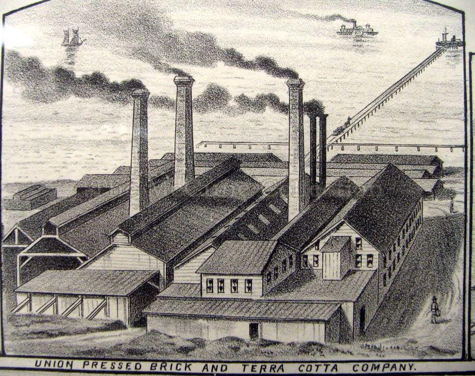 Birdseye view of Union Pressed Brick
Union Pressed Brick and Terra Cotta. It had four terra cotta and two brick kilns with ample shed room. In 1896 it was idle and by 1915 had been abandoned for a number of years. The clay which was used came from the Vallejo vicinity and were commonly described as the best made on the west coast.
Residence of C.T.B. Hallin, Georgia St. (Closeup)
Residence of C.T.B. Hallin. Hallin was a prominent member of the Masonic Lodge and had a business in the Oddfellows building on Georgia St.
Residence of James Brownlie (Closeup)
Residence of James Brownlie. James Brownlie was a prominent grocer in Vallejo. He was born in 1836 in Scotland but moved to California in 1858. After mining for a year, he worked at Mare Island as a carpenter and joiner until 1869 when he established his grocery business.
John Brownlie Hardware
John Brownlie Hardware. John Brownlie (1833-1908) was born in Scotland but came to California via Panama in 1852. He became a county supervisor. In addition, he ran a hardware store located in the Oddfellows building on Marin St, had a livery stable, and was a real estate agent. His son, JamesW. Brownlie, became a prominent physician and president of the board of health.
Philadelphia Brewery (Closeup)
Philadelphia Brewery. This brewery was established in South Vallejo in 1870 by F. Dininger. It could brew up to thirty-six barrels of beer at a time by the steam process. At its site, it contained a three story building with a basement. There was also a kiln and malt cellar. The proprietor originally from Bavaria came to California in 1856
Farrigut Theatre (Closeup)
Farragut Theatre. This was built by Mare Island’s Commandant David G. Farragut in 1869 as a hall. It was located on lower Georgia Street and had a capacity of 800 seats with a stage. It was one of the most commodious halls in the county and was often used for large meetings and gatherings.
Port Costa Lumber Yard Vallejo Junction (Closeup) Port Costa Lumber Yard Sourth Vallejo (Closeup)
Port Costa Lumberyard at Vallejo Junction. This wharf was near what was called Port Chicago (6 miles NE of Martinez). It was owned by the Port Costa Lumber Co. The lumberyard was established to serve the wholesale outlets in the Napa and Sonoma valleys. It was established with a long wharf to unload the deep sea-going sailing vessels directly and had 3000 feet of waterfront. It received pine boards from Puget Sound and redwood boards from Northern California. Port Costa Lumberyard shipped lumber to Southern California, Arizona and New Mexico and as far as New York.
USS Charleston
USS Charleston. A protected cruiser launched in 1888 by the Union Iron Works in San Francisco. The Charleston cleared Mare Island on April 10, 1890 to join the Pacific Squadron as its flagship.
USS San Francisco
USS San Francisco. A protected cruiser launched in 1889 by the Union Iron Works in San Francisco. The San Francisco left to join the Pacific Squadron in March 1891 to become its flagship.
Amador
Amador. Built in 1869 for $150,000 as a sidewheel riverboat for the California Steam Navigation Co., it first journey was from San Francisco to Stockton. It moved cargo and passengers along the Sacramento River. It was rebuilt in 1878 as a ferry but was finally retired in 1904. It was then purchased from the Southern Pacific Company by the Boating Association of the University of California at Berkeley to be used as a floating clubhouse for its rowing crews. In 1915, the Amador was finally destroyed by being blown up at the Panama-Pacific Exposition as a demonstration of the harbor defense system.
Headings for illustrations of map:

- West to East: Mare Island. Trinity to Marin
North to South: Louisiana to Georgia 
- West to East: Mare Island. Sutter to Santa Clara.
North to South: Kentucky to Georgia 
- North to South: Mare Island. Virginia to Maine

- West to East: Mare Island. Trinity to Santa Clara
North to South: Ohio to Georgia. 
- West to East: Mare Island. Trinity to Sutter
North to South: Indiana to Virginia 
- West to East: Mare Island. Branciforte to Marin
North to South: Capitol to Pennsylvania 
- West to East: Mare Island. Trinity to Amador
North to South: Indiana to York 
- West to East: Butte to Sonoma
North to South: Indiana to Carolina 
- West to East: Butte to Branciforte
North to South: Kentucky to Virginia 
- West to East: Branciforte to Santa Clara
North to South: Virginia to Georgia 
- West to East: Santa Clara to Marin
North to South: York to Maryland 
- West to East: Santa Clara to Sonoma
North to South: Pennsylvania to Maryland 
- West to East: Branciforte to Santa Clara
North to South: Florida to Georgia 
- West to East: Branciforte to Santa Clara
North to South: Carolina to Virginia 
- West to East: Santa Clara to Sonoma
North to South: Georgia to Maryland 
- Solano Ave. to Benicia Road

- West to East : Branciforte to Sutter
North to South: Indiana to Carolina 
- West to East: Indiana to Louisiana
North to South: Sutter to Amador
#1 I.O.G.T. Home for Orphans 
- West to East: Sutter to Colusa
North to South: Kentucky to Georgia
#3 Irma School 
- West to East: Solano to Benicia
North to South: Amador to Napa
#8 Union Pressed Brick and Terra Cotta 
- West to East: Branciforte to Sonoma
North to South: Louisiana to Capitol
#4 St. Vincent Ferrer, #6 Presbyterian Church 
- West to East: Branciforte to Marin
North to South: Kentucky to Virginia
#4 St. Vincent Ferrer, #6 Presbyterian Church 
- West to East: Sutter to Colusa
North to South: Kentucky to Georgia
#3 Irma School, #7 Episcopal Church, #9 Waterworks and Engine House 
- West to East: Marin to Alameda
North to South: Florida to Georgia
#3 Irma School, #5 M.E. Church, #7 Episcopal Church 
- West to East: Branciforte to Sutter
North to South: Kentucky to Georgia
#2 Public School, #5 M.E. Church, #6 Presbyterian Church 
- West to East: Branciforte to Sutter
North to South: Louisiana to Virginia
#4 St. Vincent Ferrer, #6 Presbyterian Church 
- West to East: Trinity to Santa Clara
North to South: Alabama to Carolina
Gallery
Vallejo map (1891)Vallejo map (1891)Downtown Vallejo (1891)Vallejo map (1891) TitleLandmark LegendsLandmark LegendsI.O.G.T. Home for Orphans (Closeup)IRMA School for Girls (Closeup)St. Vincent Ferrer Church (Closeup)M.E. Church (Closeup)Union Pressed Brick and Terra Cotta (Closeup)Philadelphia Brewery (Closeup)Farrigut Theatre (Closeup)Odd Fellows Hall (Closeup)Residence of James Brownlie (Closeup)Port Costa Lumber Yard Vallejo Junction (Closeup)Port Costa Lumber Yard Sourth Vallejo (Closeup)Residence of C.T.B. Hallin, Georgia St. (Closeup)Central Stable, Georgia St. (Closeup) Mare Island (1891)
 Mare Island (1891)
 Mare Island (1891)
 Mare Island
 Mare Island
 Mare Island
 Mare Island & Vallejo
 Mare Island Dry Dock
 Mare Island map illustrations
 Birdseye View of Mare Island & Vallejo
 Birdseye View of Mare Island Straits
 Birdseye View of Mare Island Straits
 Birdseye Vjo & Mare Island
 Butte & Carolina
 Carolina & Branciforte
 Georgia St Pier
 Maine & Pennsylvania Piers
 Pennsylvania Pier
 Virginia & Georgia Piers
 Virginia St Pier
 West Vallejo
 Birdseye view of Union Pressed Brick View of Tennessee St
 I.O.G.T. Home for OrphansBirdeye IRMA School for GirlsUnion Pressed Bricks
 Birdseye view of St. Vincent & Presb. Churches
 Branciforte & Capitol
 IRMA School & Episcopal Church
 M.E. Church
 M.E. Church & Presb. Church
 St. Vincent & Presb. ChurchesCorner of Carolina & Butte
 AmadorJohn Brownlie HardwareMare Island
 Mare Island Straits
 USS CharlestonUSS San Francisco